
July 16, 2024
Many city infrastructures worldwide were long ago transformed to require single-occupancy vehicles if people wanted to get around. People made due and it became a way of life, though this wasn’t accessible for some. For years, planners have theorised that a new transformation is possible, one that benefits more people, and makes for more efficient streets, healthier air, and more affordable options.
This year, students from SCARP’s PLAN 341 course may have just come up with a real plan.
The course and its students
PLAN 341 is about Smart Cities, the pursuit of analysing information about people's needs to provide those needs. Taught this past spring by SCARP PhD candidate Madison Lore (whose research identifies paths to sustainable behaviours through machine learning), this Planning course is part of UBC SCARP and UBC Geography’s Major in Urban Studies.
Urban Studies is interdisciplinary by its very nature, and these students come from many academic pursuits, including Computer Science, Computer Engineering, Electrical Engineering, Political Science, Sociology, and Urban Studies itself.
The students who produced Streetwise Solutions proudly includes:
- Hazel Chongoti
- Michael Claassen
- Kieran Freitag
- David McPherson
- Noa Nibbelink
- Ben Torry
A bold solution
As these students’ final project, they produced a plan to help sustainable transit modes thrive.
While the tool they eventually developed has potential applications worldwide, the project began as a spirited response to Vancouver’s traffic challenges. Vancouver has the second-worst traffic in Canada, at an average rate of 23 minutes for every 10 km and, on weekdays bus delays amounting 2,400 hours/day.
The students of PLAN 341 have a bold solution to this challenge: Smart Traffic Lights, which dynamically adjust green-light windows by traffic density and prioritise sustainable modes of travel, a contrast to the historical and default domination by single-use vehicles. These intersections would interface with a downloadable app in the pockets of drivers and passengers as well as on board buses (analysing how many people are present and what they’re driving) and then adjust green-light timelines to best serve the most people and the most sustainable transit. Their research carefully measured velocities, scalability, and impact over time, and the simulations the students produced is confirmed mathematically accurate.
Then, not content with merely presenting their findings, these students went above and beyond and actually created a full working simulator of their invention, as well as the hardware it would instantaneously interact with in an urban scenario.
With their simulation, the students confirmed their ability to vastly increase the number of people who can safely and easily traverse a busy intersection.
The prototype
Hazel's, Michael's, Kieran's, David's, Noa's, and Ben's Streetwise Solutions start-up incentivises public transport and carpooling (as well as emergency vehicles). Theoretically, participating cities deploying Streetwise would gradually expand public transportation infrastructure, making sustainable choices more accessible to broader populations and easing congestion.
To make Streetwise Solutions as feasible as possible, their plan takes into account data privacy, cybersecurity, possible system errors, and algorithm bias.
The tool is designed specially to be:
- Robust
Automatic failsafe: revert to normal intersection pattern - Scalable
More people using the system = better traffic management - Fair
No mandatory participation: each traffic direction has a minimum guarantee to consider those not using the system - Extendable
Can extend to include more complex traffic phasing and intersection coordination, further improving management efficiency - Transparent
Always accessible to the public
Following software and lab testing, a single intersection in Vancouver can be chosen to pilot the infrastructure, before the proof of concept is potentially rolled out on a larger scale (including the public release of the mobile app). More than a proof-of-concept simulation, Streetwise Solutions is a comprehensive plan involving government partnerships, financial models, and staggered roll-out. In short: this could happen.
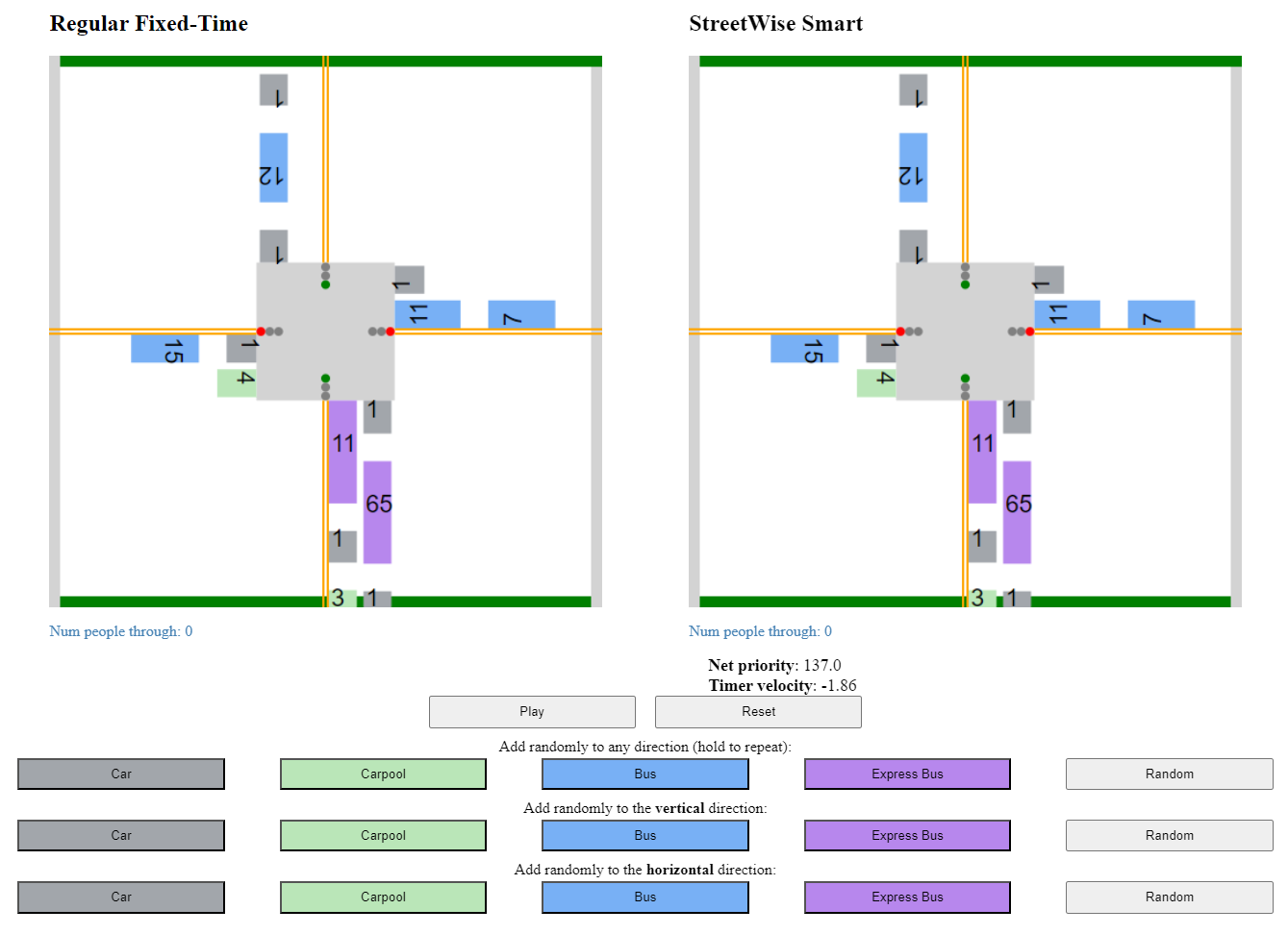
View it in action
The students have launched a demo of their simulation that you can view from home. How to use it:
- The dual interface shows how both a normal intersection and a StreetWise Solutions smart intersection would handle any scenario you throw at it.
- Select any combination of vehicles to arrive at the intersection.
- When ready, press PLAY to watch the scenario play out with or without the tool, and sum up how many people are serviced each time!
What’s possible
Implementing the scope of this plan would of course be a hardware and software feat, and of course involve strong governmental partnerships. Some may also think it requires a cultural shift in how we view transportation, but it may be a keener insight to say this tool reflects a cultural shift already underway. This model could be a catalyst for a revolution in accessibility and sustainability, one already craved by many.
Some words about the project's significance
from PLAN 341 student Kieran Freitag

"As with many others taking the smart cities class I was always interested in urbanist ideas of how we can make our cities better. I found it really engaging to work on a project where we could be at the helm of not only coming up with these ideas, but also how to be realistic in terms of implementation strategies and potential consequences.
Also, since every one of us in our group are in different majors, we were able to contribute something unique to our own skill sets. I'm in a second degree computer science program here at UBC and so I wanted to create a simulation of our idea to test its viability. This was quite fun as I was able to use the concepts I learned in my other computer science courses - such as how to appropriately model systems with objects, properties, and the relationships between them - in a more "real-life" environment with the traffic simulation.
Ultimately, I think this simulation was very helpful since it was much easier to find what works and what doesn't with our smart traffic algorithm. You can theorize about potential effects and consequences of implementing something, but the most effective way to know what happens is to actually implement it (and the second best way is through a simulation of the process)!"
Praise for the students' excellent work
from instructor Madison Lore
"The goal of the final project is to think through a Smart City solution that uses technology to improve the quality of life for people. Students need to consider cost constraints, environmental and social impacts, and evaluate their system against a criteria that measures the unintended consequences of their solution on vulnerable groups.
The students in the class produced great projects that ranged from healthcare solutions, to sustainable and efficient transportation solutions, to urban gardens and waste management solutions. Each solution included innovative aspects from the course mixed with creativity and lived experience of the students.
The Streetwise Solutions group went above and beyond to build an online simulation of their solution to illustrate its effectiveness. The group have diverse majors and passions and you can see how it came together to produce an urban smart city solution. This is representative of the different backgrounds and skill sets we need to solve some of these major urban challenges."